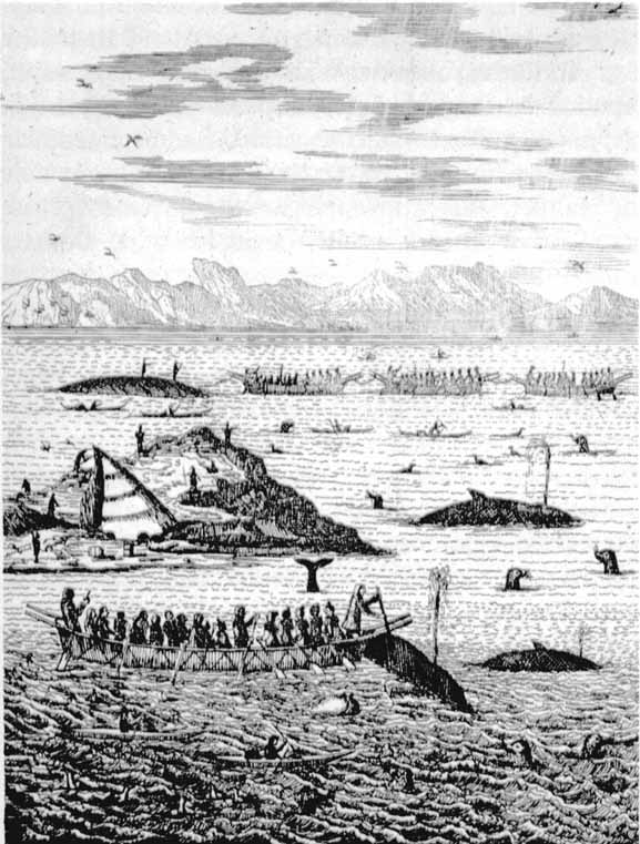
Greenland Inuit clans meeting to hunt
whales
from Description
de histoire naturelle du Groenland, by Hans Egede, tr
D.R.D.P., Copenhagen and Geneva, Frere Philibert. (Image adapted from
reproduction in Canada's
First
Nations: A
History of Founding Peoples from Earliest Times by O.P.
Dickason,
Toronto, 1992. )
This illustration of whale-hunting is impressive. It
shows
clearly just how sophisticated the northwestern Atlantic seagoing
aboriginals were in terms of having mastered a way of life harvesting
the sea. What is shown must represent the culmination of
millenia of sea-harvesting traditions specially designed for the
North Atlantic, traditions that may date back to origins in arctic
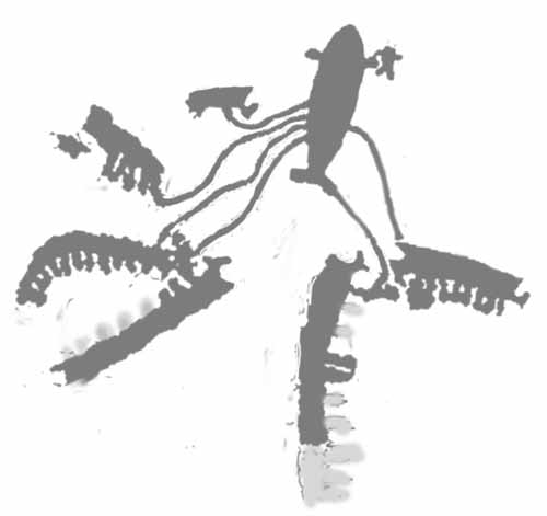
Scandinavia. I presented the following illustration from rock carvings
dating to some 5000-6000BC in
SEA-GOING SKIN BOATS
AND OCEANIC EXPANSION: The Voyages of the Whale Hunters
It is easy to imagine that the
techniques first shown in this prehistoric illustration are also
depicted in the illustration of the Greenland Inut,
Significant to
our quest for an answer to the "longhouse foundations" is the
appearance of the Greenland "Eskimo" skin boats. They have poles
on the ends, that may have been intended for handling the boat, and
there is a crosscrossing of rope on the side, which suggests the
skins are designed to be easily removed. Compare these Greenland skin
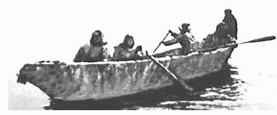
boats with an illustration of the Alaskan version. The Alaskan
umiak looks like a more permanent construction.
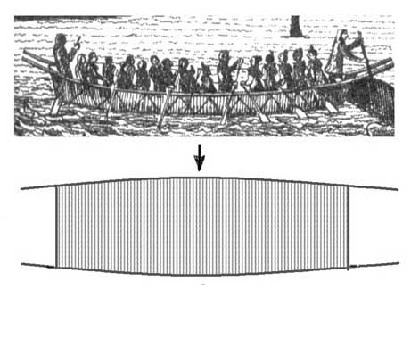
Detail from 18th century illustration of Greenland Inuit whaling
showing the sides made of two long poles, probably with skins attached.
In addition there appears to be ropes suggesting the skin was
easily removed by "unlacing". This suggests that the skin was easily
removed to be used for the purposes of creating a shelter
By contrast, the Alaskan skin boat, looks quite permanent. It lacks
features suggesting a desire to easily handle the boat and remove the
skin. Various parts of the skin may be affixed directly to
the frame here and there by pieces of rope though the skin, in contrast
to the Greenland scheme of holding the skin by pressure of the "lacing"
on the outside.
The illustration of the Greenland
"Eskimos" shows a gathering of the clans (bands, extended families) of
the sea-going tribe. Each large umiak would represent one clan, and it
appears there are four clans, which is a typical number for a natural
tribe. Among boat-using hunting people across the northern world,
a tribe would consist of some four to six clans who had
established over many generations, claims or rights to specific
hunting territories, rights which they would pass down from the clan
chief to male descendants.
THE
WAY OF LIFE OF ABORIGINALS
The manner in which clans unite to
form tribes is influenced by their circumstances. In a forest setting,
the clans might unify into a tribe if the clans each occupy a branch of
a river system. In the case of ocean-people, the pattern of ocean
currents, coasts, and winds could join a number of clans into a tribe.
The hunting territory for the seagoing peoples was
not defined in terms of land area as in civilization (based on farming
people) but in terms of specific hunting areas in the sea. The
clan would move within their own territory, from one hunting area to
another according to the patterns of nature, in a usually annual
circuit, only coming back to the same place the following
year. Each clan would defend their
territory, and respect the territories of the other clans. There
would have to be an agreement if more than one clan hunted at one
location. They moved through the environment on their own, but
congregated, usually annually, at an agreed-apon location, to
affirm their identity in the larger social order, the tribe, exchange
news, pursue celebrations, find mates. A good place for the
multi-clan meeting was where food was plentiful enough to support all
the clans together, and where it was advantageous to have help from
each other, such as hunting whales.
Each clan had their own territory, their own
number of campsites that they visited year-by-year, and they would have
guarded their rights to the animals. It is because hunting
territories, campsites, associated clans, etc were all strongly
defined, that a clan was not likely to wander aimlessly. Strange
territory meant they could be intruding on some other people's
territory and had to be on guard, proceed with caution.
It is
because of this ownership of hunting areas, that it would be difficult
for any foreigners to intrude. Any Europeans attempting to
harvest some
animal like walrus from a location a clan owned, could end up being
attacked by the entire tribe - other clans coming to the aid of the
clan experiencing trespassing. While it would not have been
difficult in recent history when Europeans had guns , early Europeans
would not have had much defence against the aboriginals if they
intruded on the aboriginal hunting territory. Any "Albans" at
well known walrus hunting sites would have been driven off It was
far easier to remain respectful and detatched towards the natives, and
get the ivory by trading some quaint European items - cloth, metal,
trinkets.
Thus the archeological features discussed by Mowat,
the seeming longhouse foundations and the beacons visible from
the sea, are much more easily explained in terms of long established
native sea-going
people of the northwest Atlantic, who spent most of their lives moving
around on the open Atlantic and harvesting large sea-animals like
whales. They would have been ancestral to the Greenland "Eskimos" and
originally archeologically "Dorset". These people would have
systemantically visited
familiar campsites year after year, in their annual
circuit, camped on rocky coasts and islands if it was needed, to
be close to their hunting places, and used methods and equipment that
had been adapted to this specialized form of life over countless
generations. With a way of life spent mostly on windblown rocky
islands, being able to use the skins of one's boats as shelter would
certainly have been part of a good system.
The boats shown in the
illustration were clearly not invented overnight, but over centuries in
adapting to the special conditions encountered in the seas off the
coasts of Greenland and Labrador.
The places where the sea animals were located were
usually far from the coast, among scattered rocky outcrop; and
so, the sea-harvesting clans needed to be able to improvise
their life on even small rocky islands not far from the hunting sites.
They would improvise shelters from very large skins that were easily
removed from frames with the long poles, by "unlacing" the rope. The
debated "longhouse foundations" may simply have been one form of
shelter, designed for open flat terrain. Elsewhere they draped the
skins against rock walls, in front of caves, etc.
HOW
SHELTERS MADE
Merely overturning umiaks produced cramped shelters.
Using skins of boats rather than whole boats gave greater
versatility and comfort in fashioning shelter. It solves the
objection of the umiak being too narrow if overturned. Possibly two
skins could be combined to create a large communal shelter for two
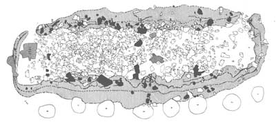
clans. Below reproduces, from
Farfarers one of
the remains of the
so-called "longhouse foundations". Note that the scattered rocks do not
show a constructed wall; and that assumptions that there was one, is
speculation. The nature of the edges, with rotten turf and stones,
could merely represent the accumulation of rocks and turf used to hold
down and seal the edges of the tent through repeated use.
Pamiok Longhouse No. 2 site after reproduction page 8 of The
Farfarers:Before the Norse, Mowat, Toronto, 1998 (The black
rocks are thought to be in their original positions)
The archeologist of the site, Tom Lee,
interpreted the distribution of rocks and turf as a broken turf and
rock wall, and used the loose rocks to build a speculative
reconstruction which is shown in
Farfarers page
7. If the skin
boat comes apart easily, if the skins can be easily removed by several
men via the poles, and if the poles themselves become supports, then we
have all the ingredients for shelter. A shelter and an umiak
cannot exist at the same time. And that is what is suggested in the
illustration - the boats appear to contain everybody (other than those
placed temporarily on rock islands) - men, women, children.
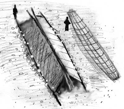
The shelter, the longhouse, may
have been made out of two umiak skins, connected to two poles each. The
base would then be held down by rocks and turf - which would explain
why nowhere have archeologists found proper walls, only loose stones
and turf. The following speculates on what was done. It requires
further research by people with more information about the traditional
Greenland umiak.
Conception of he Pamiok No. 2 site with a tent made
using 2 umiak skins including the poles that formed the skin boat
sides..
One would expect that the interior would
have had arrangements of stones for fireplaces, sleeping platforms,
etc. In my interpretation, shown in the illustration, most
of the interior stones actually belong in the interior, and the fewer
stones around the edges were never used as a wall, but simply piled on
the edges of the tent to hold down the edges. Turf pieces sealed the
cracks. Repeated use meant the site's edges always looked broken down
since they were never built up.
Who made them? Were they made by seagoing
aboriginals? Mowat records archeologist Tom Lee
saying
"I've found little in the way
of artifacts except a lot of
Dorset-culture litharge [scraps and flakes of flint] . . .Dorsets
appear to have camped here after this longhouse was abandoned."
Lee assumes the site was abandoned,
because he preconcieves a wall.
But
if there never was a wall, and it was a tent-site re-used over and over
by the Dorset people who left only their food scraps behind, then it
would agree with the concept that it was made by seagoing Dorset people
who came with a large umiak, or two per clan, pulled them ashore,
removed the skins, and erected the longhouse tent using the skins. When
they left they took everything except scraps away with them.
There never was a proper wall
The large number of such "longhouse sites" in the region
of Ungava Bay suggests it was a
congregating area for clans.
Indeed a
major hunting site was nearby. As mentioned above, while clans moved
through the environment independently, they congregated at special
locations of abundance and activity of larger scope that many clans
could better perform together. All the nomadic hunting peoples
travelled around in small extended families and then congregated at
bountiful sites where food was plenty and/or a combined effort was
reguired involving many clans - as we see above in the illustration of
Greenland aboriginal whaling. It is easy to imagine a gathering of
clans near walrus hunting grounds and hunting in a group effort for
greater efficiency.
The Cylindrical Beacons - Seemingly
Used Around the Entire North
Atlantic
Typical cylindrical pillar of rocks often over 6 ft (2 m)
tall that are best explained as markers of campsites in the annual
circuit of movement of the seagoing Dorset clans, to be seen from the
sea.
Mowat's map of the
cylindrical beacons in the Canadian arctic shows them widely
distributed on the Canadian east and arctic coast. The wide
distribution of these "beacons" -- in Ungava Bay, Hudson Strait,
eastern Hudson Bay, down the Labrador coast, etc --
cannot be
explained by occasional cross-Altantic visits by Europeans (ie
"Albans"
or Norse). They were obviously established by sea-going aboriginals of
many clans, and over many generations. They could be very old. Once
made, there was no reason to remove them. They became permanent
landmarks.
These beacons were not made by the recent
Inuit peoples, who instead erected irregular stone structures called
inuksuak made from a few
large rocks to depict a person and to signify that a human had been
there. The beacons were visible from the sea and clearly were made by
seagoing
peoples. With respect to a beacon found near the Pamiok No. 2 location,
Mowat quoted archeologist Lee as saying ".
. too big, Too
regular. Too well made. Not Eskimoan at all. And look at the thickness
of the lichen growth on them. They're too old to belong to the historic
period."
But something that is old, that predates the
newer culture, would belong to the earlier "Dorset" culture,
would it not?
Mowat continued: (p 162) "
Tower beacons
of this type are also found on Britain's Northern and Western
Isles, Iceland, western Greenland, the eastern Canadian high
arctic, the Atlantic coast of Labrador, and Newfoundland."
I add
that other sources say they can be found on the Norwegian coast
too. This means that the beacons were not merely North American
but a North Atlantic skin-boat
sea-hunter institution, as typical and widespread as the Atlantic
seagoing skin
boat itself.
Note on the following map that all these locations
mentioned by Mowat, plus Norway, circle the North Atlantic.
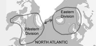
It suggests two divisions of North Atlanic seagoing aboriginal peoples,
eastern and western. I have defined these divisions acording to the
absence of islands between Iceland and Labrador and by the patterns of
the ocean currents. Mowat may want to view the makers of these beacons
as a relatively civilized seafaring people, but the truth may be that
they were largely primitive (in the sense that they were nomadic, and
lived off the sea in a self-sufficient manner), and all belonging to
the same race as the Greenland Eskimos. It is European chauvinism that
wants these people to be more like the modern seafarer of the Northern
British Isles, rather than the Eskimo/Inuit.
There is a general tendency of older generations to
dismiss aboriginal peoples, make them background decorations to the
adventures of Europeans; and as sympathetic as Mowat may be to
aboriginals, he was raised to celebrate the Norse, the British, the
European and place aboriginal peoples in a different universe.
The "beacons" are found throughout the North Atlantic (areas in the
lighter lines), and it is clear they were made by ancient
skin-boat-using aboriginal sea-harvesters of the North Atlantic, who
comrpised two divisions (heavier lines). The eastern division has
long vanished, while the western division was last represented by the
Greenland whale hunters.
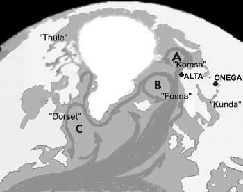
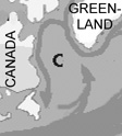
A map of the currents of the North Atlantic shows why there would
have been a natural division between eastern and western tribes. The
circling of the currents encourages one division to be set up mainly
around circuit B, and the the other in circuit C. In addition note that
the space betwen Iceland and Labrador, without islands, would discourge
travel between the two divisions, except along the coast of Greenland.
This current along Greenland , travelling east to west would
encourage peoples from B, with evolving European racial
features , to venture towards the west. The names "Dorset",
"Fosna" and "Komsa" refer to archeological designations of prehistoric
cultures in these areas, their artifacts seen along the coasts and
islands. I propose they were all related and ultimately has the same
origins.
These beacons, placed to be
visible from the sea, thus marked the locations of campsites for the
nomadic sea-going aboriginals of the North Atlantic. Once an ideal
campsite location was established, it would be reused over and
over, year after year, and thus it was useful to construct
beacons visible from the sea, in order to find the place again and
again.
Conclusions
Mowat's
The
Farfarers:Before the Norse, (Mowat, Toronto, 1998 )
presents much good information from his research, but his
analysis is not scholarly. He began with an idea of peoples from his
Scottish heritage riding in skin boats and using the boats as shelters,
and basically did what all bad scholars do - organize and select data
in order to 'prove' a preconcieved idea, and resist abandoning it when
the research did not really support the idea as he originally, naively,
concieved it.
Proper scholarship only entertains a general
question and tries not to predict the solution. The question is "How
were the longhouses suggested in the archeological finds made, and who
made them?" He may have originally thought the Norse made them, thus he
did change course once before beginning the book in his imagining an
earlier people, he decided to call "Albans". But the research really
did not support such a simple, narrow, interpretation. But could he
back out now? His publisher was waiting for a book!
There is a good story for "Albans" of Roman times,
including their possibly being the origins of Beothuks, but for the
centuries after the Roman Age, there is less and less basis for
contacts with North America by a single group. More likely the North
American evidence represents footprints made by a number of groups,
from traders who kept their journeys secret and established a couple of
trading posts, to groups of monks creating a settlement on
Newfoundland, to early settlers who were not Norse, but Finnic (the
original north European boat people), to random accidental visits by
lost Icelandic fishermen. The reality behind the diverse information he
collected from his research is far more complex than his simplistic
theory about a hypothetical "Alban" people.
He may have sensed alternative paths for the book, but was
forced to continue on the "Alban" path, and thus created something that
is more fantasy than fact, and has been treated that way.
I believe there are three major stories in the accumulated
evidence - the story of Roman Age native British, the story of North
Atlantic seagoing aboriginal peoples, and the story of contact by
northern traders, not even mentioned by Mowat. And within these three
themes there are many subdivisions, both on the British side and North
American side. For example the evidence of a settlement may represent a
trading post set up by traders. The texts speaking of a settlement of
clergy may represent a genuine settlement of Irish monks, that if they
were all men, only lasted one generation. There are several major
themes each with several angles, and it may be very difficult to find
connections between the many possible themes and angles.
2016 (c) A. Pääbo. UPDATED 2016


 So
is it possible the Beothuks were the "Albans" who hunted walrus and
created the "longhouse foundations"? We note that humans are by nature
very territorial, so that Beothuks could not trespass on hunting
territory already occupied by indigenous "Dorset" culture seafarers.
That may be the reason they ended up in Newfoundland, south of the
Labrador coast and the "Dorset" peoples. We note that since the Dorset
culture sea people did not sail, but went with currents, it is possible
that they avoided travelling south past Newfoundland, on account
currents would drive them out into the open sea. By staying adequately
towards the north, if swept to sea, they would be carried back to
Greenland. See the map below showing the current circuit "C".